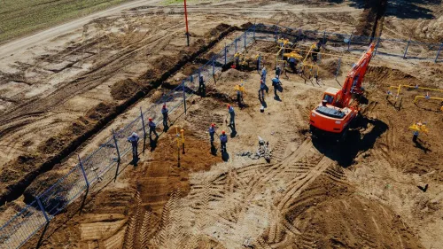

Earthwork should not begin because a plot has a sale deed or because a contractor promises to “level the site.” You need verified boundaries, mapped levels, soil data, approvals, a measurable earthwork scope, and a drainage and utility plan before excavation starts. By the end, you will know what to inspect, what to document, and what evidence to require at handover.
Key takeaways
- Confirm land records, zoning, access, setbacks, and approvals before earthwork.
- Use a topographic survey and soil investigation to select foundations and excavation methods.
- Specify earthwork quantities, compaction targets, materials, and test records in the contract.
- Map drainage, utilities, access routes, and excavation controls before machinery arrives.
Verify the Plot, Approvals, and Existing Conditions Before Earthwork
Do not allow clearing or excavation until the plot is proven buildable on paper and on the ground. A sale deed alone does not confirm the usable building area.
Complete boundary and title verification, match boundary stones to the registered site plan and survey sketch, and check for encroachments, easements, road-widening lines, lake or drain buffers, and access rights.
- Obtain the sanctioned building plan, commencement approval, approved layout, and any required tree or environmental permissions. Confirm which authority issued each approval: Bengaluru municipal limits and Devanahalli may fall under different planning authorities.
- Commission a topographic survey that records boundary coordinates, contours, spot levels, roads, walls, trees, wells, drains, poles, and a permanent benchmark tied to the design datum. Do not set finished-floor levels from one assumed site elevation.
- Locate underground electricity cables, water lines, telecom ducts, gas lines, and road services using utility records, detection equipment, and trial pits. Get written confirmation from the relevant service owners before deep excavation.
- Photograph neighbouring buildings, compound walls, roads, trees, existing cracks, drainage paths, and the plot before machinery arrives. Excavation beside a wall or road may require shoring, battered sides, underpinning, or staged digging.
- Put rock excavation, disposal location, dewatering, utility shifting, public-road restoration, survey control, and cut-and-fill measurement in the contract. Also require temporary drains, silt controls, sump locations, pump discharge routes, and protected truck access before large-scale earthwork begins.
Use Surveys and Soil Investigation to Choose the Right Groundwork Method
Choose the groundwork method from measured levels and subsurface evidence, not from a nearby project’s foundation depth. A topographic survey should record contours, spot levels, boundary coordinates, roads, drains, wells, walls, poles, and a permanent benchmark tied to the design datum. Designing from one assumed level causes ponding, excessive fill, or awkward entrance ramps.
| Ground condition | What the investigation may show | Preparation method |
|---|---|---|
| Black cotton soil | Expansive clay that swells when wet and shrinks when dry | Strip unsuitable layers; replace or stabilise them, control moisture, and obtain geotechnical foundation advice |
| Filled ground | Uncontrolled soil, demolition debris, voids, or variable density | Excavate and sort unsuitable material; place approved fill in tested lifts and compact it |
| Loose sand or wet clay | Low bearing strength, settlement risk, or difficult excavation faces | Remove and replace weak zones, improve drainage, or use an engineered treatment specified by the geotechnical engineer |
| Hard or weathered granite | Rock close to the proposed formation level | Price separate rock excavation, breaking, loading, and disposal; do not bury oversized pieces in fill |
| High groundwater | Seepage into excavations and unstable trench sides | Use a designed dewatering system, discharge route, and excavation-support method |
A soil investigation under IS 1892:2021 should use boreholes or trial pits to identify strata, rock depth, groundwater, settlement risk, and suitable fill. Classify soil under IS 1498 and verify compaction through the IS 2720 series. Compaction will not cure organic topsoil, saturated clay, or uncontrolled debris; strip, dry, stabilise, or remove them first.
Record cut, hauled, and compacted volumes separately, because excavation swell and compaction shrinkage can create a costly fill shortage.
Turn Earthwork Into a Measurable Scope With Testing Requirements
Compare quotes against one earthwork measurement sheet, not a lump-sum phrase such as “site clearing and leveling.” That sheet must state cut and fill quantities as loose excavated volume, hauled volume, and compacted fill volume.
Excavated soil swells, while compacted fill shrinks; truck counts alone can leave you short of approved fill or create unplanned disposal.
| Item | Require in quote | Check before award |
|---|---|---|
| Finished levels | Finished formation level, design datum, and survey-control responsibility | Demand section drawings tied to a permanent benchmark |
| Materials | Reusable cut, unsuitable soil, rock excavation, and imported granular fill as separate items | Confirm soil classification and approved fill source |
| Compaction | Lift thickness, moisture range, target density, and test method | Reject “95% compaction” without its reference Proctor test |
| Extras | Disposal location, dewatering limits, haul distance, and utility shifting | Identify exclusions that could become variation claims |
Specify the reference laboratory test, not just a percentage. IS 2720 Part 8 is commonly used for heavy-compaction characteristics, and IS 2720 Part 28 for the sand-replacement field density test; use the soil classification under IS 1498 where applicable.
Require a field density test at agreed locations and frequency for each relevant fill zone. Building pads, roads, utility trenches, and landscaped areas can have different acceptance criteria, so state each one in the drawings and inspection plan.
Before payment, compare pre- and post-earthwork surveys, measured quantities, test reports, moisture readings, and approved material records. A failed layer must be loosened, corrected for moisture, recompacted, and retested—not hidden beneath the next lift.
Coordinate Drainage, Access, Excavation Safety, and Buried Services
Rainwater must be controlled before large-scale excavation starts. Install temporary drainage with diversion drains, silt fences, a defined sump, and a pump discharge route; protect the truck access road with suitable aggregate. Runoff entering an open foundation can soften bearing soil, block public drains, and stop vehicle movement.
Design stormwater management around a verified legal outfall and the surrounding catchment, not by pushing water toward a boundary. Do not connect stormwater to a foul sewer or discharge it onto a neighbour’s plot. If the receiving drain is undersized, specify detention, recharge, flow control, or staged discharge before work begins.
Treat an excavation beside a boundary wall, road, or existing building as temporary works. The contractor’s method statement must identify battered slopes, shoring, sheet piles, underpinning, staged excavation, or groundwater control where required. A vertical cut at the property edge can move a neighbour’s structure even when the permanent foundation design is correct.
Retaining walls do not remove the need for temporary support during construction.
Confirm buried services before deep excavation, not after a machine exposes them. Require the following records:
- Utility-detection survey marked on the site plan
- Trial-pit locations and photographs
- Written confirmation from each service owner
- Responsibility and allowance for shifting, protection, and reinstatement
Coordinate utility connections with the excavation sequence and access route. Include rock disposal, dewatering limits, public-road restoration, and utility relocation in the contract; vague “clearing and levelling” wording invites delay claims.
Define Handover Records and Choose a Contractor for Site Delivery
Accept the site for foundation work only after the contractor proves that the approved levels, ground strength, drainage, and buried services match the design. A site handover is not complete when earthmoving stops; it is complete when test results, drawings, measurements, and outstanding defects are recorded and signed.
Require this handover package:
- A final topographic survey showing boundary coordinates, finished formation levels, slopes, access levels, permanent benchmark, and foundation reference points.
- Compaction records for each zone, stating material, lift thickness, moisture content, test location, test method, and result. “95% compaction” is incomplete without the reference Proctor test and field-density method, such as IS 2720 Part 8 and Part 28.
- As-built utility drawings showing installed, shifted, capped, or abandoned water lines, electrical cables, telecom ducts, gas lines, and drainage, referenced to fixed site points.
- Cut-and-fill measurement sheets separating excavated, hauled, compacted, rock, unsuitable soil, and imported fill volumes.
- Drainage inspection records, pump discharge routes, restored access roads, photographs, utility-owner confirmations, and a closed snag list.
Compare contractors by evidence, not the lowest lump sum:
| Check | Strong submission | Warning sign |
|---|---|---|
| Scope | Names disposal site, dewatering limits, utility shifting, and road restoration | Says “clearing and leveling” only |
| Testing | Identifies laboratories, methods, zones, and test frequency | Promises testing without records |
| Handover | Includes surveys, drawings, certificates, and defect closure | Offers verbal completion |
A professional site development contractor such as Kashi Prayag Constructions should make these records part of the contract, not an afterthought. Sign acceptance only after the engineer confirms the formation is safe for foundation excavation.
Related products
 | Renovation |
 | Electrical, Plumbing, Painting & Fabrication Works View product → |
Frequently asked questions
What should you verify before clearing or excavating a construction plot?
Check the sale deed, survey boundaries, zoning or land-use status, approved building plan, access, setbacks, drainage routes, and existing site conditions before earthwork.
Why are topographic surveys and soil investigations important?
A topographic survey establishes levels, slopes, boundaries, and drainage paths. Soil investigation identifies ground conditions that affect excavation, foundations, groundwater control, and fill selection.
How can you make earthwork measurable in a civil contract?
Define clearing limits, excavation and fill quantities, approved materials, layer thickness, moisture control, compaction targets, testing frequency, disposal locations, and as-built records.
What records should a contractor provide at site handover?
Request survey records, test reports, excavation and fill quantities, drainage details, utility confirmations, approvals, photographs, as-built drawings, and a list of outstanding work.
Related product
 | View product → |